Neotech City is part of the family of digital smart city and safe city technologies. Our solution involves capturing real-world data and transforming it into valuable information to help you understand the complexity of the surrounding environment.
Through our partnership developed with Cyclo Media Technology BV’s exclusive products and technology, we offer administrations intelligent and efficient solutions for the most common problems they face, from project planning to mobility issues or road safety problems.
Currently, our product is used in major capitals and cities such as Berlin, Vienna, Gothenburg, Bucharest, Zurich, Paris, Miami, and New York.
Safer, greener, more accessible, and smarter cities with Neotech City.

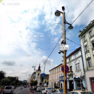
The 360-degree image, with its unique precision, saves you time to research the area of interest. They can be made virtually with Street Smart, anytime, anywhere. The basic data collection can be done directly from the image service.

Web-based usage is simple and intuitive. Geodata can be collected and maintained simply and quickly. The individual configuration of the Street Smart service offers usage based on your needs.

Street Smart Service can be connected to an existing geographic information system (GIS) as well as to many third-party systems. Existing geodata can be refined. Data can simply be exchanged between a wide range of different systems.

The unique precision allows you to evaluate the road surfaces, cross sections, markings, signage or limitation distances directly from your office.

The planning, presentation and communication of projects is simplified due to the image databases, which present the geodata and the specific projects in their real context.
The web tools of NEOTECH CITY generate a vast amount of images from the database, which are rapidly and easily accessible. Both the extracted information and the images can be accessed directly from the server, making them fast and easy to use in daily work processes.
Our data is utilized by companies in: telecommunications, construction, insurance, architecture, as well as by public authorities/governments.
We develop, build, and operate the most advanced mobile mapping systems in the world, utilizing a combination of varying camera sensors, Lidar, and state-of-the-art positioning systems to map dense urban areas worldwide.


We are delighted with every message coming from everywhere. Contact us!